Jenny is right when she says, “we will never see this the same way again.” She speaks of the Gardner River, and the park's north entrance road.
Today is the second day that visitors can enter through the north entrance (in a vehicle with a guide, or individually on foot) and have a chance to explore the damage incurred by the June 2022 historic Yellowstone flood that forever changed the river landscape.
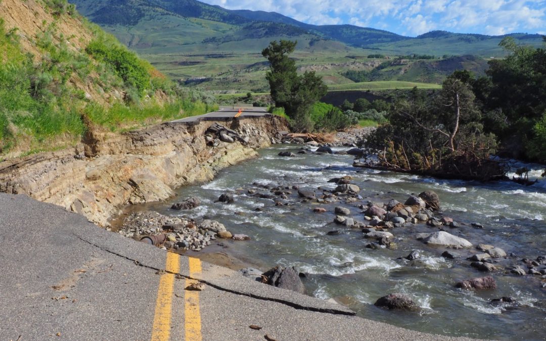
Extreme rainfall on top of late season snowmelt led to an epic, "500-year" event that caused flooding, and rock and mudslides that cut the towns of Gardiner, Silver Gate, and Cooke City, Montana off from the world. Record-high water levels inundated parts of Paradise Valley and the towns of Livingston and Red Lodge, wiped out the north entrance road between Gardiner and Mammoth Hot Springs, portions of the northeast entrance road, and closed the north and northeast entrances to the park indefinitely.
On this particular day, there are only a few other people venturing in on foot to view the damage, and all of those are locals, save one family of tourists—two adults and a pair of bored teenagers, identifiable by their unimpressed air, and the absence of water bottles, bear spray or any other essential gear. Their demeanor is in sharp contrast to our eagerness to witness the evidence left behind in the face of a spectacle that none of us could scarcely imagine was occurring on that fateful day. How has our familiar landscape changed?
The first bend of the Gardiner River, just inside the entrance gate, looks like a recently abandoned gravel pit. It was as if the usable innards of the landscape were removed and all that is left is an empty void. The entire bend for almost 100 yards is now completely flat, barely above water level, and bookended by a nearly vertical, upshot walls of collapsed earth 30 to 35 feet high. The changes are so striking, and Jenny and I have a strong desire to explore the river closer.

We leave the road in favor of walking directly on the riverbank where possible. Atop the flood deposits of sand and mud and rock are the tracks of Canada geese, a coyote, elk, deer, some pronghorn, otters and of course, grizzly bears. Life for these creatures and many others carried on in spite of the elevated flows. Of the bears, I seriously wonder if they are equipped with an atavistic memory for the sounds and scent of flooding. As consummate opportunists, I can only imagine that a river blasting out of its banks is like the sound of a dinner bell to bears, and with it, the chance to forage for less fortunate victims left behind after the waters receded. Although there has not been much news of animals caught and killed in the flow, there are always enough possibilities to draw a bear in for a closer look.


We have all seen the power of water broadcast on mass media, but until you see it for yourself, it's about like looking at a movie poster and thinking you know all the details about the show. Today's experience however, goes beyond watching the film; here is the raw, uncut footage. Despite closely studying the familiar landmarks in pictures posted by Yellowstone National Park on their Flickr account, it is impossible to grasp the full scale of what has changed, that is, until we saw it for ourselves.
Here are places that we knew intimately, ones we never could have imagined might become exposed, much less changed, or flat-out erased. The Rescue Creek hiking bridge is gone. The only evidence that it existed at all are the pylons upon which it stood and the trails that dead end on either side of the river.
The bridge itself, or what remains of it, is 50 yards down stream; it is trashed and washed up with heaps of other debris on the western shore, the only tracks nearby those of a grizzly sow and cub. As we approach it and marvel at the grizzly tracks, I breathe in the sweet petroleum stink of the creosote used to buffer its wood against the elements. My memory snaps back to more than one occasion where I laid flat on my belly upon on those same boards when they were still a bridge, peering through the cracks between them like a voyeur watching the American dippers fly beneath me; they would bounce among their favorite rocks, dipping as they went, and then dive into the mini cataracts below.
Further upstream, I climb over the trunk of a giant juniper tree. Uprooted, it is now horizontal and dying. The scent of its cedar innards permeate the air, sunlight glinting off of beads of sap upon the bark; it was taken down and throttled while still full of life and vigor. The tree's plight is far from unique.

On the day of the flood, I stood on the Yellowstone River bridge in Gardiner and took a tally for 10 minutes and chronicled 177 trees floating down the Yellowstone River. Repeating it again a a little while later, I counted 185—amounting to almost twenty tree-sized logs passing beneath the bridge over the Yellowstone River in Gardner, each minute.
A bit further along our exploration, I am happy to see an old friend who has managed to dodge this uprooted fate. Cut off from the large pullout by a channel that only recently emptied of water, this stately cottonwood tree is alive and standing and I am delighted to see it is still here. I’ve painted and drawn it so many times, walked around its impressive girth, sat in its shade, and marveled at its bloodshot orange foliage in autumn. I give it a full checkup and walk around to the upstream side. It has taken a beating. Its trunk and buttressed roots have been battered to within a hair's breadth of girdling. This is one who will remain.
Lines of flotsam on the road surface lends testimony to the water’s upper extent. Much of this smaller debris is organic in nature. I pick up a handful and examine it. Much of the contents of the flotsam are composed of conifer needles, juniper berries, the small pollen cones of pines and firs, but the lion's share is wood that has been ground to a coarse meal by the river's teeth. Beside those debris lines, huge bites are taken out of the asphalt road, cutting all the way across the historic travel route.
Chunks of the highway lay about like jagged Lego blocks while other pieces are strewn about like strips of old, nasty carpet thrown out during a renovation. The only thing giving the true identity of this debris is the white stripe from the outside of the lane, or chunks of double yellow. Still more bits lay around like the leftovers of a birthday cake in the aftermath of an eight year-old feeding frenzy. Strata of asphalt, road base and compacted layers ranging from concrete to rip rap are now exposed to the sun in head-high cross sections.
I imagine future civilizations picking up these chunks of asphalt and inferring that a travel way was built here by earlier people. They will of course, not know the stories that occurred upon those roads—the Rangers racing downhill from the park to break up fights in the now burned and repurposed bars of Gardiner, the grocery runs made before family holidays, the speeding cars carrying birthing mothers, etc.
Future people will not know of that place along a straight stretch where some years ago, a park employee sounded the whistle about a 'poacher' wearing chest waders, trying to steal the head of a deceased bighorn sheep on the far shore. The responding park ranger upon arriving said, "oh, it's you George. Want to help me get that sheep over here and remove its head so nobody else takes it?" I, the perceived poacher, had simply waded the icy, winter waters with a measuring tape and some calipers in hand to take anatomical measurements of the carcass for art reference, and nothing more. This part of the river's story and this section is largely unchanged, aside from its banks looking a bit more harsh.


Before the flood, a friend in Paradise Valley who manages a ranch and spent considerable time clearing a large, riverside field of stones twenty miles downstream of this point, in order to cultivate it. Following the flood he revisited that same field only to see it had acquired an additional twelve to fourteen inches of new soil. History lessons about ancient Egypt and the silting of the Nile delta come to mind.
As I look at these enormous cut banks, I now realize with my own senses where that amount of soil could have come from. It came from right here and so many other places in the upper Yellowstone drainage. The power of the water still so present, even though it has lowered substantially, Jenny and I have difficulty speaking with each other in anything but a yell, despite only being a few yards apart. We turn around just after crossing the first bridge over the Gardner River, which is still mostly intact.
Beyond that I wonder about the 45th parallel tree. This is a large juniper that had fallen into a horizontal position, almost spanning the entirety of the river at that time. For the last twenty years I would point to that tree and tell visitors, "look, the park service made pull outs with signs saying 45th parallel to accommodate parking and photo opps, but the real 45th parallel is where that tree leans over the river.” I wonder about that tree and resolve to come back later and forge further upstream to see if it and other familiar friends are still there. Odds are though, it is all the way down to Livingston or somewhere between at this point.

While the flood has brought much hardship to our small community—cut off from the tourist income that is the town's lifeblood—we feel dueling perspectives of compassion and worry for the folks of our community, and the awe at being present to witness a historic natural event.
Want to know how this flood fits in to previous Yellowstone floods? To put this event in perspective, we'll be hosting geomorphologist Grant Meyer to put the 2022 flood into a historical context with other epic Yellowstone floods in a presentation and Q&A session Wake of the Floods: What Extreme Events of the Past Can Tell Us About Flood Impacts, Recovery, and Climate Change in Yellowstone. A portion of proceeds will be contributed to the Yellowstone Community Fund. SIGN UP FOR THE EVENT HERE.
Images © Jenny Golding